Immaggine:Vexilographic maps of Pontic littoral by end of 13th-17th century.svg

Dimensción de quest'anteprìmma PNG pe sto file chi SVG: 800 × 437 pixel. Âtre resoluçioìn: 320 × 175 pixel | 640 × 349 pixel | 1 024 × 559 pixel | 1 280 × 699 pixel | 2 560 × 1 397 pixel | 1 640 × 895 pixel.
File òriginâle (file into formâto SVG, dimenscioìn nominâli 1 640 × 895 pixel, dimenscioìn do file: 2,58 MB)
Detàggi
| Descriçión |
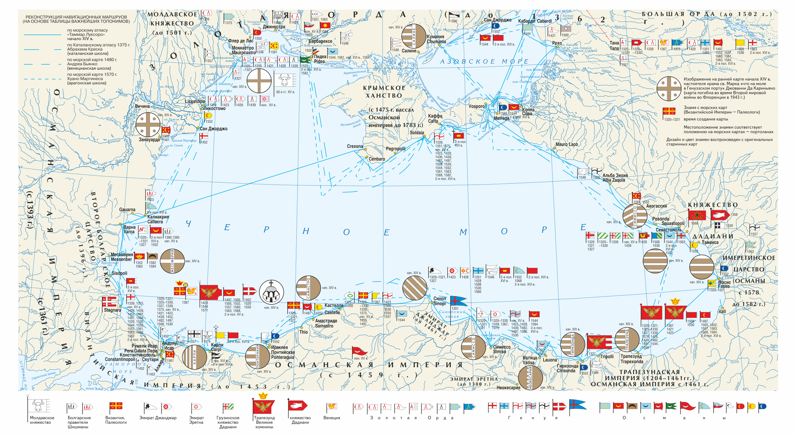
Русский: Векселлографическая карта-реконструкция Причерноморского региона «Флаги Причерноморских городов и государств по средневековым морским картам конца XIII — XVII вв.»
English: Vexilographic maps of Pontic littoral by the End of the 13th — the 17th Centuries. Territories and rulers (flags from right to left):
Key
|
| Dæta | |
| Vivàgna | Издание: Карпов С.П. История Трапезундской империи. СПб. 2007. (между стр. 32—33; 0,5 п. л.). |
| Aotô | Игорь Константинович Фоменко |
| Licénsa (Dêuviâ tórna 'sto file chi) |
Licénsa
Quésto file o l'é rilasciòu sott'a-i tèrmini da licénsa Creative Commons Atribuçión-Condivìddi a-o mæximo mòddo 3.0 Unported
- Ti t'ê lìbero:
- de condivìdde – de copiâ, distriboî e trasmétte 'st'òpera chi
- de modificâ – de adatâ l'òpera
- A-e condiçioìn chi de sótta:
- atribuçión – Ti ti dêvi atriboî a paternitæ de l'òpera, indicâ o link a-a licénsa, e indicâ se són stæti fæti di cangiaménti ascì. Ti ti pêu fâ coscì inte 'n mòddo raxonévole e de mòddo da no sugerî che quélli ch'à dæto a licénsa sostêgnan ti ò a manêa inta quæ ti t'adêuvi l'òpera.
- condivìddi a-o mæximo mòddo – Se ti càngi, trasfórmi ò svilùppi o materiâle ti dêvi distriboî i tò contribûti segóndo 'na licénsa pægia ò conpatìbile a l'òriginâle.
Cronologîa do file
Sciàcca in sce 'n grùppo dæta/ôa pe védde comm'o l'êa o file into moménto indicòu.
| Dæta/Ôa | Miniatûa | Dimenscioìn | Uténte | Coménti | |
|---|---|---|---|---|---|
| prezénte | 18:47, 28 màr 2019 | | 1 640 × 895 (2,58 MB) | Niklitov | User created page with UploadWizard |
Utilìzzo do file
A pàgina chi de sótta a contêgne di ligàmmi a sto file chi:
Utilìzzo globâle do file
Quésto file o l'é dêuviou da 'ste âtre wiki ascì:
- Dêuviòu inte pàgine de en.wikipedia.org chi de sótta:
- Dêuviòu inte pàgine de it.wikipedia.org chi de sótta:
- Dêuviòu inte pàgine de ru.wikipedia.org chi de sótta:
- Dêuviòu inte pàgine de ru.wikimedia.org chi de sótta: