Immaggine:Kingdom of Prussia 1714.svg

Dimensción de quest'anteprìmma PNG pe sto file chi SVG: 450 × 456 pixel. Âtre resoluçioìn: 237 × 240 pixel | 474 × 480 pixel | 758 × 768 pixel | 1 011 × 1 024 pixel | 2 021 × 2 048 pixel.
File òriginâle (file into formâto SVG, dimenscioìn nominâli 450 × 456 pixel, dimenscioìn do file: 893 KB)
Detàggi


.svg)
.svg)
.svg)
.svg)
.svg)


.svg)
.svg)
.svg)


.png)
.png)


.svg)


.svg)

.svg)


.svg)
.svg)
.svg)
.svg)


.svg)
.png)


.svg)


.svg)
.svg)


.svg)


.svg)


.svg)
.svg)
.svg)
.svg)
.svg)
.svg)
.svg)
_cropped.svg)
.svg)
.svg)
.svg)
.svg)
.svg)
.svg)
.svg)
.svg)
.svg)
.svg)
.svg)
.svg)
.svg)
.svg)
.svg)
.svg)
.svg)
.svg)
.svg)
.svg)
.svg)
.svg)
.svg)
.svg)
.svg)
.svg)
.svg)
.svg)
.svg)
.svg)
.svg)
.svg)
.svg)
.svg)
.svg)
.svg)
.svg)
.svg)
.svg)
.svg)
.svg)
.svg)
.svg)
.svg)
.svg)
Licénsa
Quésto file o l'é rilasciòu sott'a-i tèrmini da licénsa Creative Commons Atribuçión-Condivìddi a-o mæximo mòddo 3.0 Unported
- Ti t'ê lìbero:
- de condivìdde – de copiâ, distriboî e trasmétte 'st'òpera chi
- de modificâ – de adatâ l'òpera
- A-e condiçioìn chi de sótta:
- atribuçión – Ti ti dêvi atriboî a paternitæ de l'òpera, indicâ o link a-a licénsa, e indicâ se són stæti fæti di cangiaménti ascì. Ti ti pêu fâ coscì inte 'n mòddo raxonévole e de mòddo da no sugerî che quélli ch'à dæto a licénsa sostêgnan ti ò a manêa inta quæ ti t'adêuvi l'òpera.
- condivìddi a-o mæximo mòddo – Se ti càngi, trasfórmi ò svilùppi o materiâle ti dêvi distriboî i tò contribûti segóndo 'na licénsa pægia ò conpatìbile a l'òriginâle.
Cronologîa do file
Sciàcca in sce 'n grùppo dæta/ôa pe védde comm'o l'êa o file into moménto indicòu.
| Dæta/Ôa | Miniatûa | Dimenscioìn | Uténte | Coménti | |
|---|---|---|---|---|---|
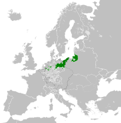
| prezénte | 21:51, 23 arv 2016 | | 450 × 456 (893 KB) | Alphathon | {{Information |Description={{en|A map of the Kingdom of Prussia in Europe circa 1714. This map also includes a border for the Holy Roman Empire (HRE).}}{{de|Eine Landkarte Preußens c. 1714.}} |Source= {{Derived from|Blank_map... |
Utilìzzo do file
A pàgina chi de sótta a contêgne di ligàmmi a sto file chi:
Utilìzzo globâle do file
Quésto file o l'é dêuviou da 'ste âtre wiki ascì:
- Dêuviòu inte pàgine de en.wikipedia.org chi de sótta:
- Dêuviòu inte pàgine de it.wikipedia.org chi de sótta:
- Dêuviòu inte pàgine de zh.wikipedia.org chi de sótta: