Immaggine:Reliefkarte Litauen.png

Dimenscioìn de st'anteprìmma chi: 776 × 600 pixel. Âtre resoluçioìn: 311 × 240 pixel | 621 × 480 pixel | 994 × 768 pixel | 1 280 × 989 pixel | 2 542 × 1 964 pixel.
File òriginâle (2 542 × 1 964 pixel, dimensción do file: 7,28 MB, tîpo MIME: image/png)
Detàggi
| Descriçión |
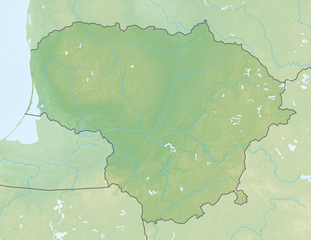
Deutsch: Reliefkarte Litauen
Topographischer Hintergrund: NASA Shuttle Radar Topography Mission (public domain). SRTM3 v.2. |
||||||||
| Dæta | |||||||||
| Vivàgna | Òpera pròpia | ||||||||
| Aotô | Tschubby | ||||||||
| Licénsa (Dêuviâ tórna 'sto file chi) |
Mi, detentô di driti d'aotô de st'œuvia, deciæo de pubricâla sotta-e seguente lisensie:
Questo file è disponibile in base alle licenze Creative Commons Attribuzione-Condividi allo stesso modo 2.5 Generico, 2.0 Generico e 1.0 Generico
Ti ti pêu çèrne a licénsa che ti ti vêu. |

Cronologîa do file
Sciàcca in sce 'n grùppo dæta/ôa pe védde comm'o l'êa o file into moménto indicòu.
| Dæta/Ôa | Miniatûa | Dimenscioìn | Uténte | Coménti | |
|---|---|---|---|---|---|
| prezénte | 09:56, 20 màz 2018 | | 2 542 × 1 964 (7,28 MB) | Tschubby | {{Information |description= |source= |date= |author= |permission= |other versions= }} |
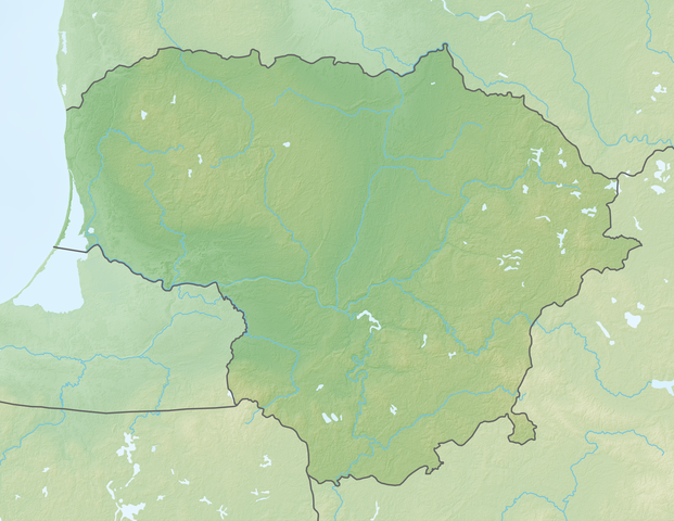
| 09:37, 19 màz 2018 |  | 2 542 × 1 964 (7,14 MB) | Tschubby | == {{int:filedesc}} == {{Information |Description= {{de| Reliefkarte Litauen}} Topographischer Hintergrund: [http://www2.jpl.nasa.gov/srtm NASA Shuttle Radar Topography Mission] (public domain). SRTM3 v.2.<br /> Flüsse: Lithuania adm location map.svg |Source={{own}} |Date= 2018-05-19 |Author= Tschubby |Permission= {{self|GFDL|Cc-by-sa-3.0-migrated|Cc-by-sa-2.5,2.0,1.0}} |other_versions= }} Category:Location maps of Lithuania [[Category:Topographic maps of Lithu... |
Utilìzzo do file
A pàgina chi de sótta a contêgne di ligàmmi a sto file chi:
Utilìzzo globâle do file
Quésto file o l'é dêuviou da 'ste âtre wiki ascì:
- Dêuviòu inte pàgine de bg.wikipedia.org chi de sótta:
- Dêuviòu inte pàgine de de.wikipedia.org chi de sótta:
- Litauen
- Wystiter See
- Fernsehturm Vilnius
- Kaunasser Meer
- Juozapinės kalnas
- Windenburger Eck
- Vorlage:Positionskarte Litauen
- Aukštojas
- Wikipedia:Kartenwerkstatt/Positionskarten/Europa
- Drūkšiai
- Wasserburg Trakai
- Pumpspeicherkraftwerk Kruonis
- Benutzer:Tomlux/Spielwiese
- Radio- und Fernsehturm Klaipėda
- Fernsehturm Tauragė
- Asveja
- Tauragnas
- Sartai
- Aisetas
- Rėkyva-See
Véddi l'ûzo globâle de quésto file.