Immaggine:Nseamap.gif
No gh'é de verscioìn a resoluçión ciù âta.
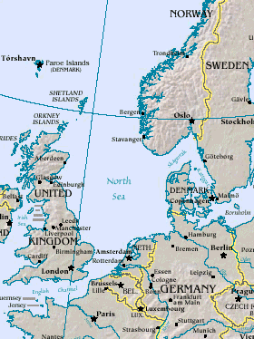
Nseamap.gif (280 × 374 pixel, dimensción do file: 43 KB, tîpo MIME: image/gif)
Map of North Sea, from the US Department of Energy: http://eia.doe.gov/emeu/cabs/northsea.html
Русский: Северное море
| This image is a work of a United States Department of Energy (or predecessor organization) employee, taken or made as part of that person's official duties. As a work of the U.S. federal government, the image is in the public domain.
Please note that national laboratories operate under varying licences and some are not free. Check the site policies of any national lab before crediting it with this tag.
|

|
Cronologîa do file
Sciàcca in sce 'n grùppo dæta/ôa pe védde comm'o l'êa o file into moménto indicòu.
| Dæta/Ôa | Miniatûa | Dimenscioìn | Uténte | Coménti | |
|---|---|---|---|---|---|
| prezénte | 16:20, 26 màr 2005 | | 280 × 374 (43 KB) | Ivan~commonswiki | Map of North Sea, from the en:US Department of Energy: [http://eia.doe.gov/emeu/cabs/northsea.html http://eia.doe.gov/emeu/cabs/northsea.html] {{PD-USGov}} |
Utilìzzo do file
A pàgina chi de sótta a contêgne di ligàmmi a sto file chi:
Utilìzzo globâle do file
Quésto file o l'é dêuviou da 'ste âtre wiki ascì:
- Dêuviòu inte pàgine de als.wikipedia.org chi de sótta:
- Dêuviòu inte pàgine de am.wikipedia.org chi de sótta:
- Dêuviòu inte pàgine de ast.wikipedia.org chi de sótta:
- Dêuviòu inte pàgine de as.wikipedia.org chi de sótta:
- Dêuviòu inte pàgine de ban.wikipedia.org chi de sótta:
- Dêuviòu inte pàgine de ba.wikipedia.org chi de sótta:
- Dêuviòu inte pàgine de be-tarask.wikipedia.org chi de sótta:
- Dêuviòu inte pàgine de csb.wikipedia.org chi de sótta:
- Dêuviòu inte pàgine de cv.wikipedia.org chi de sótta:
- Dêuviòu inte pàgine de da.wikipedia.org chi de sótta:
- Dêuviòu inte pàgine de de.wiktionary.org chi de sótta:
- Dêuviòu inte pàgine de diq.wikipedia.org chi de sótta:
- Dêuviòu inte pàgine de en.wikipedia.org chi de sótta:
- Dêuviòu inte pàgine de eo.wikipedia.org chi de sótta:
- Dêuviòu inte pàgine de gl.wikipedia.org chi de sótta:
- Dêuviòu inte pàgine de he.wikipedia.org chi de sótta:
- Dêuviòu inte pàgine de hif.wikipedia.org chi de sótta:
- Dêuviòu inte pàgine de hr.wikipedia.org chi de sótta:
- Dêuviòu inte pàgine de hu.wiktionary.org chi de sótta:
- Dêuviòu inte pàgine de id.wikipedia.org chi de sótta:
- Dêuviòu inte pàgine de is.wikipedia.org chi de sótta:
- Dêuviòu inte pàgine de it.wikipedia.org chi de sótta:
- Dêuviòu inte pàgine de it.wikibooks.org chi de sótta:
- Dêuviòu inte pàgine de ja.wikipedia.org chi de sótta:
- Dêuviòu inte pàgine de jv.wikipedia.org chi de sótta:
- Dêuviòu inte pàgine de ka.wikipedia.org chi de sótta:
- Dêuviòu inte pàgine de kw.wikipedia.org chi de sótta:
- Dêuviòu inte pàgine de lt.wikipedia.org chi de sótta:
- Dêuviòu inte pàgine de ml.wikipedia.org chi de sótta:
- Dêuviòu inte pàgine de mn.wikipedia.org chi de sótta:
- Dêuviòu inte pàgine de mwl.wikipedia.org chi de sótta:
- Dêuviòu inte pàgine de nn.wikipedia.org chi de sótta:
- Dêuviòu inte pàgine de olo.wikipedia.org chi de sótta:
- Dêuviòu inte pàgine de pl.wiktionary.org chi de sótta:
- Dêuviòu inte pàgine de pt.wikipedia.org chi de sótta:
- Dêuviòu inte pàgine de roa-tara.wikipedia.org chi de sótta:
- Dêuviòu inte pàgine de ru.wikipedia.org chi de sótta:
- Dêuviòu inte pàgine de ru.wiktionary.org chi de sótta:
- Dêuviòu inte pàgine de sah.wikipedia.org chi de sótta:
- Dêuviòu inte pàgine de sco.wikipedia.org chi de sótta:
- Dêuviòu inte pàgine de simple.wikipedia.org chi de sótta:
Véddi l'ûzo globâle de quésto file.