Immaggine:Description De Mexico et des Lagunes De Ses Environs Gemelli Careri.jpg

Dimenscioìn de st'anteprìmma chi: 759 × 599 pixel. Âtre resoluçioìn: 304 × 240 pixel | 608 × 480 pixel | 973 × 768 pixel | 1 280 × 1 011 pixel | 1 646 × 1 300 pixel.
File òriginâle (1 646 × 1 300 pixel, dimensción do file: 1,62 MB, tîpo MIME: image/jpeg)
Detàggi
| Descriçión |
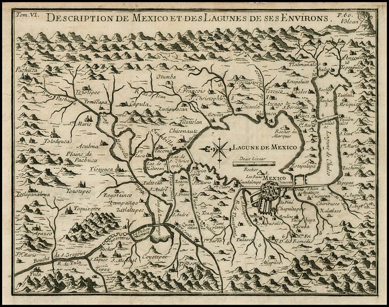
English: "Rare map of the area around Mexio City, centered on the large Lagune de Mexico and extends to include the surrounding mountains, rivers, towns and villages, reportedly derived from a copy an original native map while Careri was in Mexico. The map is drawn on a partial bird's-eye format, with an imaginary horizon that includes an erupting volcano at upper right. Many villages are located including Pachuca, Tacoma, Atlapilco, Tolodyuca, Tetlapanaloya, and Apazco. Careri's account states that the map is a copy of a map drawn by Charles Siguenza of an original drawn by native Americans. The Mexicans were told to search for a place that would be shown to them by the presence of an eagle standing on a cactus growing out of a rock. This place is Tenochtitlán or the present-day Mexico City. The present map is from an edition of Careri's account published in Paris. The work also appears in Churchill's collection of voyages and travels, published in London, 1704." |
| Dæta | |
| Vivàgna | Voyage du Tour du Monde (1719, Paris: French Translation of "Giro Del Mondo"). |
| Aotô | Gemelli Careri |
Licénsa
Mi, detentô di driti d'aotô de st'œuvia, deciæo de pubricâla sotta-a seguente lisensia:
| Questo file è reso disponibile nei termini della licenza Creative Commons CC0 1.0 Universal. | |
| La persona che ha associato un'opera con questo atto legale ha donato tale opera nel pubblico dominio rinunciando a tutti i diritti sull'opera in tutto il mondo, inclusi tutti i diritti connessi o altri diritti simili, per quanto permesso dalla legge. Puoi copiare, modificare, distribuire ed utilizzare l'opera, anche a fini commerciali, senza chiedere alcun permesso.
|
Cronologîa do file
Sciàcca in sce 'n grùppo dæta/ôa pe védde comm'o l'êa o file into moménto indicòu.
| Dæta/Ôa | Miniatûa | Dimenscioìn | Uténte | Coménti | |
|---|---|---|---|---|---|
| prezénte | 01:18, 5 màz 2011 | | 1 646 × 1 300 (1,62 MB) | Dottos | {{Information |Description ={{en|1="Rare map of the area around Mexio City, centered on the large Lagune de Mexico and extends to include the surrounding mountains, rivers, towns and villages, reportedly derived from a copy an original native map while |
Utilìzzo do file
A pàgina chi de sótta a contêgne di ligàmmi a sto file chi:
Utilìzzo globâle do file
Quésto file o l'é dêuviou da 'ste âtre wiki ascì:
- Dêuviòu inte pàgine de en.wikipedia.org chi de sótta:
- Dêuviòu inte pàgine de fr.wikipedia.org chi de sótta:
- Dêuviòu inte pàgine de kn.wikipedia.org chi de sótta: