Immaggine:Continental West Germanic languages.png

Dimenscioìn de st'anteprìmma chi: 462 × 600 pixel. Âtre resoluçioìn: 185 × 240 pixel | 370 × 480 pixel | 591 × 768 pixel | 789 × 1 024 pixel | 1 796 × 2 332 pixel.
File òriginâle (1 796 × 2 332 pixel, dimensción do file: 539 KB, tîpo MIME: image/png)

|
This file requires updating because: "complety" to "completely" In doing so, you could add a timestamp to the file.
|


|
Questa immagine (categorizzazione automatica: linguistic map) o tutte le immagini in questa categoria o galleria dovrebbero essere ricreate usando grafica vettoriale come file SVG. Questo offre diversi vantaggi: vedi Commons:Media for cleanup per maggiori informazioni. Se è disponibile una versione in formato SVG di questa immagine, per favore caricala. Dopo aver caricato un file SVG, sostituisci questo avviso con il template {{Vector version available|nome_immagine.svg}}.
|
| Descriçión |
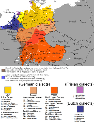
English: The dialectal ranges (not those of standard languages!) of the Continental West Germanic languages (Dutch/Frisian/German) after 1945 |
||
| Vivàgna |
|
||
| Aotô | Rex Germanus | ||
| Licénsa (Dêuviâ tórna 'sto file chi) |
|

Cronologîa do file
Sciàcca in sce 'n grùppo dæta/ôa pe védde comm'o l'êa o file into moménto indicòu.
| Dæta/Ôa | Miniatûa | Dimenscioìn | Uténte | Coménti | |
|---|---|---|---|---|---|
| prezénte | 01:04, 26 set 2023 | | 1 796 × 2 332 (539 KB) | Гинц фон Гинценфельд | In dieser Version ist die Westfälische Linie genauer markiert. |
| 00:52, 26 set 2023 |  | 1 796 × 2 332 (538 KB) | Гинц фон Гинценфельд | In dieser Version ist die Westfälische Linie genauer markiert. | |
| 13:26, 25 set 2023 |  | 1 796 × 2 332 (535 KB) | Гинц фон Гинценфельд | In dieser Version ist die Westfälische Linie genauer markiert. | |
| 22:01, 8 agó 2017 |  | 898 × 1 166 (166 KB) | E-960 | Corrected location of city markers | |
| 11:19, 6 màz 2017 |  | 898 × 1 166 (166 KB) | E-960 | Updated map to focus on Germany and the Benelux, also removed out of date areas, due to migration back to Germany after the fall of the Iron Curtain. | |
| 19:49, 4 fre 2017 |  | 1 028 × 1 196 (193 KB) | E-960 | Added place name of Wien, and Český Krumlov in local language. | |
| 19:11, 4 fre 2017 |  | 1 028 × 1 196 (193 KB) | E-960 | Adjusted place names reverting them to the local language of each individual country, also fixed the border between Belarus and Ukraine, and areas of German minority in Central and Eastern Europe. | |
| 19:07, 12 agó 2016 |  | 1 028 × 1 196 (154 KB) | Kontrollstellekundl | corr: Salzbaurg -> Salzburg Krummau -> Krumau Luxemburgish -> Luxembourgish Upper Sacon -> Upper Saxon + placement of various names | |
| 14:15, 28 lùg 2014 |  | 1 028 × 1 196 (107 KB) | Crom daba | Shaded sub-dialect groupings a bit different so that they can be differentiated at a glance | |
| 23:57, 4 set 2010 |  | 1 028 × 1 196 (132 KB) | Hans Erren | Geographic border corrections (Borkum, Markerwaard) Western ripuarian border corrected |
Utilìzzo do file
A pàgina chi de sótta a contêgne di ligàmmi a sto file chi:
Utilìzzo globâle do file
Quésto file o l'é dêuviou da 'ste âtre wiki ascì:
- Dêuviòu inte pàgine de ace.wikipedia.org chi de sótta:
- Dêuviòu inte pàgine de af.wikipedia.org chi de sótta:
- Dêuviòu inte pàgine de azb.wikipedia.org chi de sótta:
- Dêuviòu inte pàgine de be-tarask.wikipedia.org chi de sótta:
- Dêuviòu inte pàgine de bg.wikipedia.org chi de sótta:
- Dêuviòu inte pàgine de ce.wikipedia.org chi de sótta:
- Dêuviòu inte pàgine de da.wikipedia.org chi de sótta:
- Dêuviòu inte pàgine de de.wikipedia.org chi de sótta:
- Dêuviòu inte pàgine de en.wikipedia.org chi de sótta:
- Dêuviòu inte pàgine de en.wikivoyage.org chi de sótta:
- Dêuviòu inte pàgine de es.wikipedia.org chi de sótta:
- Dêuviòu inte pàgine de fa.wikipedia.org chi de sótta:
- Dêuviòu inte pàgine de fr.wikipedia.org chi de sótta:
- Dêuviòu inte pàgine de ga.wikipedia.org chi de sótta:
- Dêuviòu inte pàgine de hr.wiktionary.org chi de sótta:
- Dêuviòu inte pàgine de id.wikipedia.org chi de sótta:
- Dêuviòu inte pàgine de ja.wikipedia.org chi de sótta:
- Dêuviòu inte pàgine de mk.wikipedia.org chi de sótta:
- Dêuviòu inte pàgine de mn.wikipedia.org chi de sótta:
- Dêuviòu inte pàgine de pnb.wikipedia.org chi de sótta:
- Dêuviòu inte pàgine de ro.wikipedia.org chi de sótta:
- Dêuviòu inte pàgine de ru.wikipedia.org chi de sótta:
- Dêuviòu inte pàgine de simple.wikipedia.org chi de sótta:
- Dêuviòu inte pàgine de sl.wikipedia.org chi de sótta:
- Dêuviòu inte pàgine de sr.wikipedia.org chi de sótta:
- Dêuviòu inte pàgine de sv.wikipedia.org chi de sótta:
- Dêuviòu inte pàgine de uk.wikipedia.org chi de sótta:
- Dêuviòu inte pàgine de zh-min-nan.wikipedia.org chi de sótta: